-
Hey, guest user. Hope you're enjoying NeoGAF! Have you considered registering for an account? Come join us and add your take to the daily discourse.
You are using an out of date browser. It may not display this or other websites correctly.
You should upgrade or use an alternative browser.
You should upgrade or use an alternative browser.
Hurricane Season 2010: Getting a jump on June 1st
- Thread starter Xeke
- Start date
- Status
- Not open for further replies.
jamesinclair
Banned
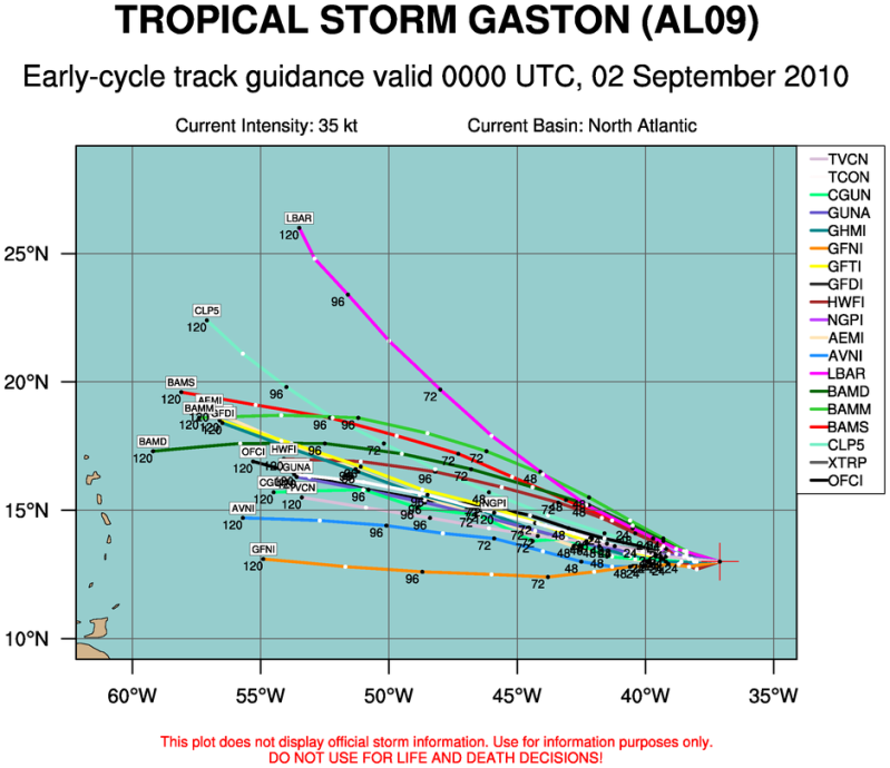
Poor little islands. Looks like Gaston will eat them all 
jamesinclair said:Poor little islands. Looks like Gaston will eat them all
Heh, I think this is the big one for us in the islands. Has all the makings for it. Strong high. Warm water. Some dry air and shear is expected but if it develops an Anti Cyclone no shear will matter.
Well, Earl is our focus now...
SATELLITE AND RECONNAISSANCE AIRCRAFT FIXES INDICATE THAT EARL
HAS BEEN MOVING RELENTLESSLY TOWARD THE NORTHWEST OR 310 DEGREES
AT 15 KNOTS. THE HURRICANE IS ABOUT TO REACH THE WESTERN EDGE OF
THE SUBTROPICAL RIDGE AND SHOULD BEGIN TO TURN MORE TO THE
NORTH-NORTHWEST AND NORTH LATER TONIGHT AND THURSDAY. IN ABOUT 36
HOURS OR SO...THE HURRICANE WILL ENCOUNTER THE BASE OF THE
MID-LATITUDE WESTERLIES AND SHOULD BEGIN TO RECURVE OR TURN TO THE
NORTHEAST WITH AN INCREASING FORWARD SPEED. THIS IS THE SOLUTION
CONSISTENTLY PROVIDED BY TRACK MODELS...WHICH HAVE EARL PASSING TO
THE EAST BUT NOT FAR FROM THE OUTER BANKS OF NORTH CAROLINA ON
THURSDAY NIGHT. ONLY A SMALL WESTWARD DEVIATION OF THE TRACK TO THE
WEST WOULD BRING THE CORE OF THE HURRICANE TO THE COAST.
jamesinclair
Banned
Posting for this page

Smiles and Cries
Member
BAH HUMBUG!


Dead Prince
Banned
They are going to run a train on you guys
DMPrince said:They are going to run a train on you guys
Wtf just saw that 10% what the hell is everything coming out gonna form :lol
Relix said:Wtf just saw that 10% what the hell is everything coming out gonna form :lol
Shits gonna get crazy.
Looks like there's Tropical Storm Warnings posted up the Delaware Bay.
I didn't live out here when Isabel caused all sorts of ruckus and was hoping to see a little Hurricane action. I grew up with the squall lines common in the Midwest and was hoping to see what a hurricane is like. I was kind of a weather nerd when I was a kid so it's on my list of things to experience....
I think all but one model show it just clipping the Delmarva peninsula, but I keep hoping somehow that it will hang a little further west. So.... smart weather people (...Relix...), what's your best ballpark/shot-in-the-dark guess of Earl slamming the Delaware/Jersey shore?
Spike Spiegel
Member
It's like all the tropical systems got held up in customs, and now they're all leaving the airport at the same time.
Spike Spiegel said:It's like all the tropical systems got held up in customs, and now they're all leaving the airport at the same time.
The tropicals have been jacking off for months now and it's time for them to blow their load.
Xeke said:The tropicals have been jacking off for months now and it's time for them to blow their load.
Cape Verde is pumping out more babies than Momma Duggar. At this rate, she'll get her own Discovery Channel program.
HylianTom said:Cape Verde is pumping out more babies than Momma Duggar. At this rate, she'll get her own Discovery Channel program.
Yeah it's like the season kicked into overdrive.
Retro said:Looks like there's Tropical Storm Warnings posted up the Delaware Bay.
I didn't live out here when Isabel caused all sorts of ruckus and was hoping to see a little Hurricane action. I grew up with the squall lines common in the Midwest and was hoping to see what a hurricane is like. I was kind of a weather nerd when I was a kid so it's on my list of things to experience....
I think all but one model show it just clipping the Delmarva peninsula, but I keep hoping somehow that it will hang a little further west. So.... smart weather people (...Relix...), what's your best ballpark/shot-in-the-dark guess of Earl slamming the Delaware/Jersey shore?
Well, the system is being nudged a bit west by another upper level system. The trough is still not there to make it go north and as the NHC said... any west wobbles and we have a huge disaster. That small wobble could be going on now. It wobbled north earlier, it's wobbling west now. That happens all the time. But the extent of the wobble is what can change the expected path. I am not saying it's gonna ram into NC and then NYC, but Earl has the potential to be a disaster and here's why..
- It will soon begin to skirt the EC
- It has the Gulf Stream energy all for its disposal. This means that even if half the hurricane is over land if the center is over warm waters the land friction won't do shit on the intensity.
- The trough is supposed to come tomorrow and pull it north. In the meanwhile any wobbles west will be potentially disastrous.
Xeke said:Yeah it's like the season kicked into overdrive.
Experts said it, I said it... etc. It was expected. There was no way this was a low activity season. It seems at the beginning the atmosphere dynamics were a bit fucked. That's why we got a warm Canada and a heatwave in Russia. It's all related. Now as soon as we get back to normal and you've got every single wave coming off Africa developing. It's like 2005 but instead of the Caribbean and Gulf they now come from CV.
Oh and by the way....
I am getting hammered soon. Hard.


sneakypete
Member
Pardon my ignorance, but how long until the East Coast starts feeling Earl? Specifically SC/NC?
jamesinclair
Banned
Nom nom nom
Smiles and Cries
Member
oh this is just great it gets stronger?
Relix said:Well, the system is being nudged a bit west by another upper level system. The trough is still not there to make it go north and as the NHC said... any west wobbles and we have a huge disaster. That small wobble could be going on now. It wobbled north earlier, it's wobbling west now. That happens all the time.
Right, I mean... the damn things go wherever they can and the forecasts are never solid until a day before they hit. I think it was Diana (I can't be sure, I do know I saw it on a weather special in the late 80s) that made landfall, rolled out to sea, doubled back and made a second landfall later in the day.
I was very surprised to see that only three tropical storms have made direct landfall on the Delmarva Peninsula, I would have expected more.
Smiles and Cries
Member

this is a little more wind than I was hoping for in CT
Almighty_Chocobo
Member
jamesinclair said:Nom nom nom
Cannot unsee. :lol
spindashing
Banned
Almighty_Chocobo said:Cannot unsee. :lol
:lol :lol :lol Neither can I.
I feel bad for people living in the eastern part of NYC, damn..
sw33tclyde said:Pardon my ignorance, but how long until the East Coast starts feeling Earl? Specifically SC/NC?
Around 18 hours and you start receiving bands. After that and you get the real deal.
Neuromancer
Member
Yep me too brotherBad_Boy said:its like a giant butthole about to shit on the east coast. :lol
my plans are not changing though, i intend to be at the beach this saturday. hopefully earl is far away by then.
If it passes 75W then things get worse. If it does pass 76W then expect even worse. It's not a matter of IF... it's a matter of when and how strong. It's an inminent impact to the EC, direct or indirect, and everyone along the path will feel it. Now, let's see how long he takes to make that north turn. That's the determining factor and the trough is the only one capable of doing that... and it's still taking some time to get there.
EDIT: Heh, he just did a westward wobble. Oh boy... if anyone from GAF is in that area you better be prepared.
EDIT: Heh, he just did a westward wobble. Oh boy... if anyone from GAF is in that area you better be prepared.
Miggytronz
Member
oh boy here we go!
im in Va beach, VA.....
I'll post pics of anything crazy that i may witness.
im in Va beach, VA.....
I'll post pics of anything crazy that i may witness.
Relix said:EDIT: Heh, he just did a westward wobble. Oh boy... if anyone from GAF is in that area you better be prepared.
Define "That Area".... you mean the NC Coast about to come under fire, or the entire east coast?
Retro said:Define "That Area".... you mean the NC Coast about to come under fire, or the entire east coast?
Entire East Coast. He will do what some would call a catastrophic storm. The reasoning is the west side will stay over land with Hurricane Force winds and the eye stays in the gulf stream feeding himself with hot water so he never weakens and you get Cat 3+ winds all the way until the stream ends. That's the potential. And of course the closer he gets the stronger the effect. There's no question he will turn north, the point is WHEN. Timing is the crucial factor once more.
Calantus said:hopefully the projected path is right, its gonna be really weak(relative to now) before it hits ground. And it won't come inward towards me in NC
i'm about 80 miles off the coast of NC, and i work until 8 tonight, hopefully it's not too bad then.
Tropical Storm winds extend up to 200 miles dude, and in the current track he's about 40 miles off the coast so 40+80=120.... yeah you get tropical storm winds.
littleworm
Member
What do you think we should expect in the Wilmington area?Relix said:If it passes 75W then things get worse. If it does pass 76W then expect even worse. It's not a matter of IF... it's a matter of when and how strong. It's an inminent impact to the EC, direct or indirect, and everyone along the path will feel it. Now, let's see how long he takes to make that north turn. That's the determining factor and the trough is the only one capable of doing that... and it's still taking some time to get there.
EDIT: Heh, he just did a westward wobble. Oh boy... if anyone from GAF is in that area you better be prepared.
Lionheart1827
Member
Smiles and Cries said:
this is a little more wind than I was hoping for in CT
Shit man I'm in the red zone of long island.
lawblob said:So NYC is projected to get no action? That sucks; I want a mega-storm damnit!
NYC will get 55+mph winds. Or more.
littleworm said:What do you think we should expect in the Wilmington area?
Hurricane Winds in excess of 75mph and even more depending on track. Western eyewall landfall possible, unlikely perhaps. If that happened expect 140+mph winds.
Guys do remember I am just an enthusiast so follow NHC's track and recommendations. I am just giving estimates based on what I know and am seeing.
sneakypete
Member
Calantus said:hopefully the projected path is right, its gonna be really weak(relative to now) before it hits ground. And it won't come inward towards me in NC
i'm about 80 miles off the coast of NC, and i work until 8 tonight, hopefully it's not too bad then.
I'm about to go into work myself, won't get off 'til 9. The great part? I'm delivering pizzas at the moment so I'll be driving around in whatever Earl brings.
Relix said:Guys do remember I am just an enthusiast so follow NHC's track and recommendations. I am just giving estimates based on what I know and am seeing.
If I'm killed because of your misinformation you'll be hearing from my lawyers. :lol
Seriously though, I don't think anyone is taking the hurricane thread on a gaming forum as gospel. But it is nice to have someone with even an enthusiast's knowledge of meteorology to give opinions. We did the same damn thing in the Snowpocalypse thread this past winter.
As I mentioned earlier in the thread, I was a weather geek when I was a kid (I taped Weather Channel specials, followed storms, saved newspaper clippings) and some of that has carried into adulthood. I find all of this very interesting and I like to think that I 'get' most of the technical stuff that most people don't understand... so the conversation and regular updates in this thread are really enjoyable.
I grew up in the Midwest where there was plenty of action, but never anything as event-like as a hurricane. Since I've moved to the east coast, I've been quietly hoping to see what a Tropical storm is like. It's just a shame I live in the Mid-Atlantic which rarely gets hit directly.
Retro said:If I'm killed because of your misinformation you'll be hearing from my lawyers. :lol
Seriously though, I don't think anyone is taking the hurricane thread on a gaming forum as gospel. But it is nice to have someone with even an enthusiast's knowledge of meteorology to give opinions. We did the same damn thing in the Snowpocalypse thread this past winter.
As I mentioned earlier in the thread, I was a weather geek when I was a kid (I taped Weather Channel specials, followed storms, saved newspaper clippings) and some of that has carried into adulthood. I find all of this very interesting and I like to think that I 'get' most of the technical stuff that most people don't understand... so the conversation and regular updates in this thread are really enjoyable.
I grew up in the Midwest where there was plenty of action, but never anything as event-like as a hurricane. Since I've moved to the east coast, I've been quietly hoping to see what a Tropical storm is like. It's just a shame I live in the Mid-Atlantic which rarely gets hit directly.
I would rather have 50 snowpocalypses than a tropical storm.
sw33tclyde said:I'm about to go into work myself, won't get off 'til 9. The great part? I'm delivering pizzas at the moment so I'll be driving around in whatever Earl brings.
Might get some sweet tips. Also, bring a raincoat?
silentspork
Member
Alucrid said:It's a good thing that I have shithole New Jersey to act as a buffer for the storm. :lol
And what paradise are you from?

ISS024-E-012815 (30 Aug. 2010) -- Photographed by an Expedition 24 crew member on the International Space Station, this is an oblique view that shows the eye (just left of center) of Hurricane Earl (at this time a category 4 but later downgraded to a category 3), centered just north of the Virgin Islands near 19.3 north latitude and 64.7 west longitude packing 115-kilometer winds. A Russian Soyuz vehicle is docked to the station (foreground). The photo was taken with a digital still camera using a 55mm lens.
It's 2 days old photo but still looks gorgeous
NHC will have to move the track westward. The trough is not picking up Earl at the moment. It's moving very slow in the middle of USA.
On related news!
It's Official:
President Declares Emergency For North Carolina
Release Date: September 2, 2010
Release Number: HQ-10-168
» More Information on North Carolina Hurricane Earl
WASHINGTON, D.C. -- The head of the U.S. Department of Homeland Securitys Federal Emergency Management Agency (FEMA) Craig Fugate announced today that Federal aid is available to supplement state and local response efforts due to the emergency conditions resulting from Hurricane Earl beginning on September 1, 2010, and continuing.
The President's action authorizes the Department of Homeland Security, Federal Emergency Management Agency (FEMA), to coordinate all disaster relief efforts which have the purpose of alleviating the hardship and suffering caused by the emergency on the local population, and to provide appropriate assistance for required emergency measures, authorized under Title V of the Stafford Act, to save lives and to protect property and public health and safety, and to lessen or avert the threat of a catastrophe in Beaufort, Bertie, Camden, Chowan, Columbus, Craven, Currituck, Dare, Gates, Hyde, New Hanover, Onslow, Pamlico, Pasquotank, Perquimans, Pitt, Tyrrell, and Washington Counties.
Specifically, FEMA is authorized to identify, mobilize, and provide at its discretion, equipment and resources necessary to alleviate the impacts of the emergency. Emergency protective measures, including direct Federal assistance, will be provided at 75 percent Federal funding.
Smiles and Cries said:
this is a little more wind than I was hoping for in CT
Ah fuckles. I work for the power company (UI) ... we're gonna get boned and I'm going to work all weekend.
000
WTNT32 KNHC 021139
TCPAT2
BULLETIN
HURRICANE EARL INTERMEDIATE ADVISORY NUMBER 32A
NWS TPC/NATIONAL HURRICANE CENTER MIAMI FL AL072010
800 AM EDT THU SEP 02 2010
...INTENSE HURRICANE EARL CONTINUES ON A NORTH-NORTHWESTWARD
TRACK...EXPECTED TO PASS NEAR THE OUTER BANKS TONIGHT...
SUMMARY OF 800 AM EDT...1200 UTC...INFORMATION
----------------------------------------------
LOCATION...30.1N 74.8W
ABOUT 355 MI...575 KM S OF CAPE HATTERAS NORTH CAROLINA
ABOUT 820 MI...1315 KM SSW OF NANTUCKET MASSACHUSETTS
MAXIMUM SUSTAINED WINDS...145 MPH...230 KM/HR
PRESENT MOVEMENT...NNW OR 330 DEGREES AT 18 MPH...30 KM/HR
MINIMUM CENTRAL PRESSURE...932 MB...27.52 INCHES
WATCHES AND WARNINGS
--------------------
CHANGES WITH THIS ADVISORY...
NONE.
SUMMARY OF WATCHES AND WARNINGS IN EFFECT...
A HURRICANE WARNING IS IN EFFECT FOR...
* BOGUE INLET NORTH CAROLINA NORTHEASTWARD TO THE NORTH
CAROLINA/VIRGINIA BORDER INCLUDING THE PAMLICO AND ALBEMARLE
SOUNDS.
A HURRICANE WATCH IS IN EFFECT FOR...
* NORTH OF THE NORTH CAROLINA/VIRGINIA BORDER TO CAPE HENLOPEN
DELAWARE.
* WESTPORT TO PLYMOUTH MASSACHUSETTS...INCLUDING MARTHAS
VINEYARD AND NANTUCKET.
A TROPICAL STORM WARNING IS IN EFFECT FOR...
* CAPE FEAR TO WEST OF BOGUE INLET NORTH CAROLINA.
* NORTH OF THE NORTH CAROLINA/VIRGINIA BORDER TO SANDY HOOK NEW
JERSEY...INCLUDING DELAWARE BAY SOUTH OF SLAUGHTER BEACH AND THE
CHESAPEAKE BAY SOUTH OF NEW POINT COMFORT.
* THE COAST OF LONG ISLAND NEW YORK FROM FIRE ISLAND INLET NORTHWARD
AND EASTWARD TO PORT JEFFERSON HARBOR.
A TROPICAL STORM WATCH IS IN EFFECT FOR...
* SANDY HOOK NEW JERSEY TO WOODS HOLE MASSACHUSETTS...INCLUDING
BLOCK ISLAND AND LONG ISLAND SOUND.
* THE COAST OF LONG ISLAND NEW YORK WEST OF FIRE ISLAND INLET AND
PORT JEFFERSON HARBOR.
* NORTH OF PLYMOUTH MASSACHUSETTS TO EASTPORT MAINE.
* THE COAST OF NOVA SCOTIA FROM PORT MAITLAND TO MEDWAY HARBOUR.
FOR STORM INFORMATION SPECIFIC TO YOUR AREA IN THE UNITED
STATES...INCLUDING POSSIBLE INLAND WATCHES AND WARNINGS...PLEASE
MONITOR PRODUCTS ISSUED BY YOUR LOCAL NATIONAL WEATHER SERVICE
FORECAST OFFICE. FOR STORM INFORMATION SPECIFIC TO YOUR AREA OUTSIDE
THE UNITED STATES...PLEASE MONITOR PRODUCTS ISSUED BY YOUR NATIONAL
METEOROLOGICAL SERVICE.
DISCUSSION AND 48-HOUR OUTLOOK
------------------------------
AT 800 AM EDT...1200 UTC...THE EYE OF HURRICANE EARL WAS LOCATED
NEAR LATITUDE 30.1 NORTH...LONGITUDE 74.8 WEST. EARL IS MOVING
TOWARD THE NORTH-NORTHWEST NEAR 18 MPH...30 KM/HR BUT A TURN TOWARD
THE NORTH IS EXPECTED SOON. A TURN TOWARD THE NORTH-NORTHEAST AND
AN INCREASE IN FORWARD SPEED IS EXPECTED ON FRIDAY. ON THE
FORECAST TRACK...THE CENTER OF EARL WILL PASS NEAR THE NORTH
CAROLINA OUTER BANKS TONIGHT...AND BE VERY NEAR SOUTHEASTERN NEW
ENGLAND FRIDAY NIGHT.
MAXIMUM SUSTAINED WINDS REMAIN NEAR 145 MPH...230 KM/HR...WITH
HIGHER GUSTS. EARL IS A CATEGORY FOUR HURRICANE ON THE
SAFFIR-SIMPSON HURRICANE WIND SCALE. A GRADUAL WEAKENING IS
EXPECTED TO START LATER TODAY...BUT EARL IS EXPECTED TO BE A MAJOR
HURRICANE WHEN IT PASSES NEAR THE OUTER BANKS.
HURRICANE-FORCE WINDS EXTEND OUTWARD UP TO 90 MILES...150 KM...FROM
THE CENTER...AND TROPICAL-STORM-FORCE WINDS EXTEND OUTWARD UP TO 230
MILES...370 KM.
THE MINIMUM CENTRAL PRESSURE ESTIMATED FROM THE HURRICANE HUNTER
DATA IS 932 MB...27.52 INCHES.
HAZARDS AFFECTING LAND
----------------------
WINDS...TROPICAL-STORM-FORCE WINDS ARE EXPECTED TO REACH THE NORTH
CAROLINA COAST WITHIN THE WARNING AREA BY THIS AFTERNOON. EVEN IF
THE CENTER OF EARL REMAINS OFFSHORE...HURRICANE FORCE WINDS ARE
EXPECTED TO OCCUR ON THE OUTER BANKS BY THURSDAY NIGHT.
TROPICAL-STORM-FORCE WINDS WILL LIKELY REACH THE COAST FROM
VIRGINIA NORTHWARD TO NEW JERSEY BY LATE THURSDAY NIGHT OR EARLY
FRIDAY.
STORM SURGE...A DANGEROUS STORM SURGE WILL RAISE WATER LEVELS BY AS
MUCH AS 3 TO 5 FEET ABOVE GROUND LEVEL WITHIN THE HURRICANE WARNING
AREA AND THE LOWER CHESAPEAKE BAY. ELSEWHERE WITHIN THE TROPICAL
STORM WARNING AREA...STORM SURGE WILL RAISE WATER LEVELS BY AS MUCH
AS 1 TO 3 FEET ABOVE GROUND LEVEL. NEAR THE COAST...THE SURGE WILL
BE ACCOMPANIED BY LARGE AND DESTRUCTIVE WAVES.
RAINFALL...ACCUMULATIONS OF 2 TO 4 INCHES...WITH ISOLATED
MAXIMUM AMOUNTS OF 6 INCHES...ARE EXPECTED OVER PORTIONS OF EASTERN
NORTH CAROLINA INCLUDING THE OUTER BANKS. ACCUMULATIONS OF 1 TO 2
INCHES ARE POSSIBLE FARTHER TO THE NORTH ALONG THE IMMEDIATE
MID-ATLANTIC COAST.
SURF...LARGE SWELLS FROM EARL WILL CONTINUE TO AFFECT THE BAHAMAS
AND THE EAST COAST OF THE UNITED STATES THROUGH FRIDAY. THESE
SWELLS WILL LIKELY CAUSE DANGEROUS SURF CONDITIONS AND RIP
CURRENTS.
NEXT ADVISORY
-------------
NEXT COMPLETE ADVISORY...1100 AM EDT.
$$
FORECASTER AVILA
------
Discussion
000
WTNT42 KNHC 021456
TCDAT2
HURRICANE EARL DISCUSSION NUMBER 33
NWS TPC/NATIONAL HURRICANE CENTER MIAMI FL AL072010
1100 AM EDT THU SEP 02 2010
THERE HAS BEEN NO SIGNIFICANT CHANGES IN THE STRUCTURE OF EARL
DURING THE PAST FEW HOURS. HOWEVER..MICROWAVE INAGERY SUGGEST THAT
AN EYEWALL REPLACEMENT COULD OCCUR SOON...IN WHICH CASE THE WIND
FIELD WOULD BECOME LARGER. THE HURRICANE CONTINUES WITH A DISTINCT
EYE SURROUNDED BY DEEP CONVECTION. SATELLITE INTENSITY ESTIMATES
AND DATA FROM A RECONNAISSANCE AIRCRAFT A FEW HOURS AGO INDICATE
THAT THE INITIAL INTENSITY IS 120 KNOTS. EARL PROBABLY HAS ALREADY
REACHED ITS PEAK INTENSITY AND IT SHOULD SOON BEGIN TO WEAKEN
GRADUALLY AS THE SHEAR INCREASES. THE HURRICANE SHOULD WEAKEN EVEN
FASTER AFTER 36 HOURS...AS IT MOVES OVER A COLDER OCEAN. EARL
SHOULD BECOME EXTRATROPICAL BY 72 HOURS AND DISSIPATE THEREAFTER AS
IT BECOMES ABSORBED BY A MUCH LARGER EXTRATROPICAL CYCLONE.
AS ANTICIPATED...EARL HAS BEGUN TO MOVE NORTHWARD OR 355 DEGREES AT
16 KNOTS. SINCE THE STEERING PATTERN HAS NOT CHANGED...EARL IS
FORECAST TO CONTINUE NORTHWARD TODAY. IN ABOUT 24 HOURS...THE
HURRICANE SHOULD BE ENCOUNTERING THE BASE OF THE MID-LATITUDE
WESTERLIES AND EARL SHOULD THEN TURN MORE TOWARD THE NORTH-NORTHEAST
AND NORTHEAST WITH AN INCREASE IN FORWARD SPEED. THIS SHARP TURN
HAS BEEN CONSISTENTLY INDICATED FOR THE PAST COUPLE OF DAYS IN THE
OFFICIAL FORECAST AND BY THE TIGHTLY CLUSTERED TRACK GUIDANCE.
FORECAST POSITIONS AND MAX WINDS
INITIAL 02/1500Z 30.9N 74.8W 120 KT
12HR VT 03/0000Z 33.5N 75.0W 115 KT
24HR VT 03/1200Z 36.5N 73.5W 100 KT
36HR VT 04/0000Z 40.0N 70.8W 85 KT
48HR VT 04/1200Z 44.0N 67.0W 65 KT
72HR VT 05/1200Z 53.5N 62.0W 40 KT...POST-TROP/EXTRATROP
96HR VT 06/1200Z...ABSORBED BY A LARGE EXTRATROPICAL LOW
Lateraleye
Member
Mikasangelos said:oh boy here we go!
im in Va beach, VA.....
I'll post pics of anything crazy that i may witness.
I'm also in VB. If you live at the beach you might see some crazy waves, otherwise it'll be a yawner here. Barely any rain, maybe a decent gust or two, next to nil flooding. I'm (not so) secretly very disappointed!
11AM update - it's officially going north. The NHC forecast has been spot on the entire time even with the unpredictability of that trough.
negreenfield
Member
Last time I was in North Carolina's outer banks during a hurricane was Bob, that was probably close to 20 years ago (man I'm getting old). The winds I think hit around 60 mph or so and the house swayed a bit. I thought it was kind of cool at that age. This one looks like it could be much worse.
- Status
- Not open for further replies.