-
Hey, guest user. Hope you're enjoying NeoGAF! Have you considered registering for an account? Come join us and add your take to the daily discourse.
You are using an out of date browser. It may not display this or other websites correctly.
You should upgrade or use an alternative browser.
You should upgrade or use an alternative browser.
Atlantic Hurricane season 2017 |OT|
- Thread starter perfectchaos007
- Start date
maabus1999
Member
The one saving grace with Maria is it's much more an Andrew than an Irma. The worst of it will be highly contained.
Successful ERC's can change that over time.
12Z GFS run ongoing. 48 hour prediction is more west slightly but unfortunately over part of PR.
Chaplain
Member
‘Rapidly Instensifying' Hurricane Maria Takes Aim at Puerto Rico, Virgin Islands (NBC News, Sep 18, 2017, 11:57 AM ET)
Hurricane Maria was strengthening as it barreled towards Martinique and Puerto Rico on Monday while the Irma-battered Caribbean islands braced for the arrival of yet another potentially powerful storm.
As of 11 a.m., Maria had grown into a "rapidly intensifying" Category 3 storm with maximum sustained winds of 120 mph and was about 60 miles east of Martinique, a French island that is home to some 400,000 people, the National Hurricane Center said.
Maria could grow into a "major hurricane" by Monday night or early Tuesday as it takes aim at Puerto Rico's southern coast, the hurricane center said.
maabus1999
Member
Latest MARIA GFS run is slightly slower and more west than previous runs long term. This trend is slightly worrying as increases probability of a landfall path on eastern seaboard.
EDIT: Looks like a coastal NC landfall for MARIA on this GFS run before turning slowly...definitely shifted the storm westerly.
EDIT: Looks like a coastal NC landfall for MARIA on this GFS run before turning slowly...definitely shifted the storm westerly.
Doesn't Jose dying quickly increase the danger of Maria going toward Florida?
Oh boy
Latest MARIA GFS run is slightly slower and more west than previous runs long term. This trend is slightly worrying as increases probability of a landfall path on eastern seaboard.
EDIT: Looks like a coastal NC landfall for MARIA on this GFS run before turning slowly...definitely shifted the storm westerly.
Going to come right at Florida watch. This shit sounds exactly like Irma so far with everyone saying it's going to the Carolinas at first. Expecting the worst yet again.
Netherscourge
Banned
Is there any detrimental effect for all the churning going on with the Middle Atlantic Ocean this year?
So many powerful storms cutting though makes me wonder. Or do Hurricanes mostly just affect the upper layers of the ocean?
Seeing ocean water pulled back off of beaches for some half-mile or so exposing the floor after Irma was pretty amazing. Even for High-Low Tide's sake. Makes me wonder if anything is going on in the middle Atlantic other than some angry fish being tossed and turned.
Is there any detrimental effect for all the churning going on with the Middle Atlantic Ocean this year?
So many powerful storms cutting though makes me wonder. Or do Hurricanes mostly just affect the upper layers of the ocean?
Seeing ocean water pulled back off of beaches for some half-mile or so exposing the floor after Irma was pretty amazing. Even for High-Low Tide's sake. Makes me wonder if anything is going on in the middle Atlantic other than some angry fish being tossed and turned.
What Happens Underwater During a Hurricane?
But below the ocean's surface, the currents and turbulence beneath those waves can also be quite destructive. Unlike places above the surface, the ocean doesn't ”forget" about the storm very quickly... strong currents and turbulence have been known to exist up to a week after the storm passes overhead. Damaging currents can extend down to at least 300 feet below the surface, capable of dismantling coral reefs, relocating ship wrecks, breaking oil pipelines, and displacing huge volumes of sand on the seabed.
ryūkotsusei
Member
How do you solve a problem like Maria?
With Chaos Emeralds.
Epsilon-delta
Banned
We might have to do this song and dance again.The models are starting to take Jose dying off quicker than expected into account. Seeing way more hits to the Carolina's and a select few showing Florida hits now.
I really don't like how similar this is looking to Irma.
I get that referenceHow do you solve a problem like Maria?
mingoguaya
Member
If i had a anxiety attack over Irma and the eye did not even hit me in aguadilla.....jesus fucking christ.
Yeah we were lucky last time. Not this time, though.
Oh nice. I live near the 110, really close to San Antonio.
Aguadilla-Gaf representing. 😁
perfectchaos007
Member
What sucks about about a cat4 hitting PR as opposed to the Florida Keys is....PR residents can't evacuate. If PR residents could evacuate, the weather service would be sending out tweets like this to get residents to evacuate. 3,500,000 people live on the island

Vestal
Gold Member
12z Euro just started. Let's see what it does after the GFS shifted west and the UKMet shifted east.
All of them are on CRACK. I would say throw all of the models away past day 4.. Euro has Jose as a well defined tropical system with a great eye on simulated Infrared on day 6(Hell somehow Jose intensifies on this run lol).. Jose won't last 2 days let alone 6.
Too much uncertenty this far out.. We will have a much better picture Wednesday once it is past PR in regards to its track past the islands after the models take into account a non existent Jose.
What sucks about about a cat4 hitting PR as opposed to the Florida Keys is....PR residents can't evacuate. If PR residents could evacuate, the weather service would be sending out tweets like this to get residents to evacuate. 3,500,000 people live on the island
PR wouldn't be completely underwater like the Keys.
quackamole
Member
Seems like NYC will be spared most of Jose, only getting some rain tomorrow.
Vestal
Gold Member
PR wouldn't be completely underwater like the Keys.
PRs infrastructure however is not as good as that of Florida, nor do they have easy access to help from the main land if the infrastructure collapses(it probably will). Add to that the high potential of flooding, mudslides and violent surge... You get the picture.
PRs infrastructure however is not as good as that of Florida, nor do they have easy access to help from the main land if the infrastructure collapses(it probably will). Add to that the high potential of flooding, mudslides and violent surge... You get the picture.
I was specifically talking about the Keys, which is what that "REAL AS IT GETS" tweet was about.
From what I understand, the Keys were completely trashed by Irma like some of the smaller Caribbean islands. I don't think the infrastructure there held up too well.
All of them are on CRACK. I would say throw all of the models away past day 4.. Euro has Jose as a well defined tropical system with a great eye on simulated Infrared on day 6(Hell somehow Jose intensifies on this run lol).. Jose won't last 2 days let alone 6.
Too much uncertenty this far out.. We will have a much better picture Wednesday once it is past PR in regards to its track past the islands after the models take into account a non existent Jose.
Seems like we were here just two weeks ago. Irma into New York. Irma into DC. Irma into the Carolinas. The trend south and west each day until it zeroed in on Florida. I'm really not looking forward to going through this shit again. Supply chains are still stressed and not really fully recovered. Shelves for canned goods are still not fully stocked. Grabbed a few packs of water from Costco today just in case.
Seems like we were here just two weeks ago. Irma into New York. Irma into DC. Irma into the Carolinas. The trend south and west each day until it zeroed in on Florida. I'm really not looking forward to going through this shit again. Supply chains are still stressed and not really fully recovered. Shelves for canned goods are still not fully stocked. Grabbed a few packs of water from Costco today just in case.
Yeah. Bad memories
Vestal
Gold Member
Seems like we were here just two weeks ago. Irma into New York. Irma into DC. Irma into the Carolinas. The trend south and west each day until it zeroed in on Florida. I'm really not looking forward to going through this shit again. Supply chains are still stressed and not really fully recovered. Shelves for canned goods are still not fully stocked. Grabbed a few packs of water from Costco today just in case.
I would say don't worry about the track to the US Mainland until at least Thursday to be honest. There won't be any certainty or at least somewhat certainty until then.
Right now with the effects of what there is of Jose left has created a real mess in the long range track. Anything past 4 days is hot garbage right now.
Speaking of Jose it's possible it pulls a Nadine 2012 where it goes post-tropical and regenerates as a tropical storm since it's likely the shear hammering the storm right now will weaken if it starts moving southward a few days from now. The current NHC forecast shows it dipping southward again as a post-tropical storm a few days from now.
Also some models are starting to show Maria and whatever remains of Jose merging or dancing around each other like a week from now.

VanMardigan
has calmed down a bit.
Where do you find the graphs that predict the wind speed moving forward? I'm trying to see what the expected wind speeds are for Maria when it gets closest to st. Croix.
Randolph Freelander
Member
Maria now a cat 4 at 130 MPH. Somewhat surprised she's only that, given that the system has looked even more impressive since the 2pm update.
5:00 PM AST Mon Sep 18
Location: 15.1°N 60.7°W
Moving: WNW at 9 mph
Min pressure: 950 mb
Max sustained: 130 mph
FORECAST POSITIONS AND MAX WINDS
INIT 18/2100Z 15.1N 60.7W 115 KT 130 MPH
12H 19/0600Z 15.7N 61.9W 125 KT 145 MPH
24H 19/1800Z 16.5N 63.3W 135 KT 155 MPH
36H 20/0600Z 17.3N 64.7W 135 KT 155 MPH
48H 20/1800Z 18.2N 66.2W 130 KT 150 MPH...OVER PUERTO RICO
72H 21/1800Z 20.0N 69.0W 125 KT 145 MPH...OVER WATER
96H 22/1800Z 22.0N 71.5W 120 KT 140 MPH
120H 23/1800Z 25.0N 73.0W 105 KT 120 MPH
Maria now a cat 4 at 130 MPH. Somewhat surprised she's only that, given that the system has looked even more impressive since the 2pm update.
5:00 PM AST Mon Sep 18
Location: 15.1°N 60.7°W
Moving: WNW at 9 mph
Min pressure: 950 mb
Max sustained: 130 mph
FORECAST POSITIONS AND MAX WINDS
INIT 18/2100Z 15.1N 60.7W 115 KT 130 MPH
12H 19/0600Z 15.7N 61.9W 125 KT 145 MPH
24H 19/1800Z 16.5N 63.3W 135 KT 155 MPH
36H 20/0600Z 17.3N 64.7W 135 KT 155 MPH
48H 20/1800Z 18.2N 66.2W 130 KT 150 MPH...OVER PUERTO RICO
72H 21/1800Z 20.0N 69.0W 125 KT 145 MPH...OVER WATER
96H 22/1800Z 22.0N 71.5W 120 KT 140 MPH
120H 23/1800Z 25.0N 73.0W 105 KT 120 MPH
I think the NHC is being conservative. We should be getting some recon soon to verify.
perfectchaos007
Member
NE side of PR will be in much worse shape than the SW side of PR by the looks of it from the forecast. San Juan residents may want to evacuate to Mayaguez or south of Mayaguez
Rebel Leader
THE POWER OF BUTTERSCOTCH BOTTOMS
There are
WAY TOO MANY STORMS GETTING THIS STRONG THIS FAST
WAY TOO MANY STORMS GETTING THIS STRONG THIS FAST
We haven't being hit by one this strong in almost a 100 years. Stories about this hurricane will be told for a long, long time in the island. It'll also hit during daytime, which is unique for me, as all hurricanes I've experienced had been at night.
maabus1999
Member
Speaking of Jose it's possible it pulls a Nadine 2012 where it goes post-tropical and regenerates as a tropical storm since it's likely the shear hammering the storm right now will weaken if it starts moving southward a few days from now. The current NHC forecast shows it dipping southward again as a post-tropical storm a few days from now.
Also some models are starting to show Maria and whatever remains of Jose merging or dancing around each other like a week from now.
Euro is already way off on Jose intensity so most folks on weather forums aren't buying this one too much. honestly Jose is really screwing with all the models and most likely they are over analyzing it.
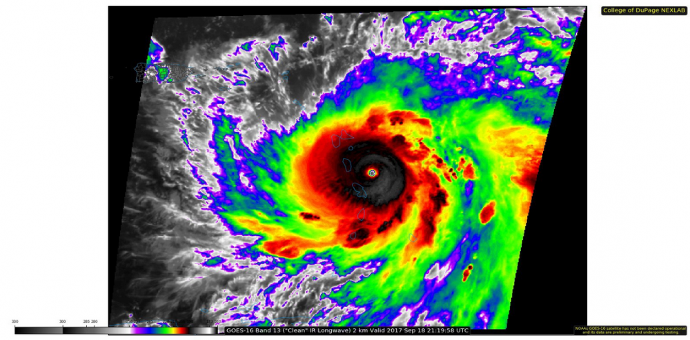
This storm was a tropical storm just over a day ago...look at it now with a Raw T at 7.1 now(!!!):
The best forecasts for Hurricane Irma came from a computer model few people know about
Of the massive, high-powered computer models run by governments and institutions to forecast hurricanes, the vaunted European model had the best performance during Irma. But theres a little-known entity that preliminary data show outperformed the European model as well as the others.
Enter Panasonic, the electronics company best known for making televisions.
Panasonic has a subgroup in its aviation division, known as Panasonic Avionics, that works on a weather model. The models foundation is based on the National Weather Services well-known Global Forecast System model, often referred to as the American model.
But the Panasonic model is beefed up with additional data, not incorporated into the GFS, that may be helping it produce even more accurate forecasts. Panasonic gained access to this valuable data after acquiring AirDat in 2013, a company that engineers instruments aboard commercial jets that gather weather data.
On balance, forecast data released by Panasonic reveals its forecasts were the most accurate leading up to Irmas landfall on Marco Island, Fla. (Note that this forecast data, provided by Panasonic, has not been independently evaluated. But Panasonic has posted the data online and welcomes scholars to review it.)

Looking at the latest images of Maria I think we will see her upgraded to cat 5 with the next recon. She has a stunning pinhole eye at the moment and the raw numbers ADT numbers are smack on for a good cat 5. PR might be about to take a real hammering as well as all the other islands. Poor people.
aspiegamer
Member
925 extrapolated. This is almost certainly category 5 now.
VanMardigan
has calmed down a bit.
Damn you guys are really scaring me with this cat 5 talk
Damn you guys are really scaring me with this cat 5 talk
VanMardigan
has calmed down a bit.
Martinique here (just south of Dominica). Shit is getting real.
What is incredible is how fast this went from Cat 1 to Cat 4 right now.
The worse should be in a few hours, and we're lucky we will likely not in the eye trajectory...
Stay safe
Yep, Cat 5.
Hurricane Maria Tropical Cyclone Update
NWS National Hurricane Center Miami FL AL152017
745 PM AST Mon Sep 18 2017
...HURRICANE HUNTER AIRCRAFT FIND MARIA AS CATEGORY 5 HURRICANE ON
THE SAFFIR-SIMPSON HURRICANE WIND SCALE...
Air Force Reserve hurricane hunter aircraft data indicate Hurricane
Maria has intensified into an extremely dangerous Category 5
hurricane on the Saffir-Simpson Hurricane Wind Scale with maximum
winds of 160 mph (260 km/h) with higher gusts. A special advisory
will be issued at 800 PM AST (0000 UTC) in lieu of the scheduled
intermediate advisory for Maria.
SUMMARY OF 745 PM AST...2345 UTC...INFORMATION
---------------------------------------------------
LOCATION...15.3N 61.1W
ABOUT 15 MI...25 KM ESE OF DOMINICA
ABOUT 40 MI...70 KM N OF MARTINIQUE
MAXIMUM SUSTAINED WINDS...160 MPH...260 KM/H
PRESENT MOVEMENT...WNW OR 290 DEGREES AT 9 MPH...15 KM/H
MINIMUM CENTRAL PRESSURE...929 MB...27.43 INCHES
Randolph Freelander
Member
Dang.
StopMakingSense
Member
wtf
Dominica is going to get obliterated like the Virgin Islands. Direct hit is imminent in the next few hours.Martinique here (just south of Dominica). Shit is getting real.
What is incredible is how fast this went from Cat 1 to Cat 4 right now.
The worse should be in a few hours, and we're lucky we will likely not in the eye trajectory...
Stay safe. Luckily the eye is small and the core winds don't extend far right now
Talk about escalation, holy shit. We at least saw Irma coming from a mile away as it gathered strength in the open ocean. Maria seemingly has exploded in a couple days from a tropical depression to a full blown cat 5?
Maybe a mod can edit the title from yesterday on Maria, indicating that it's a Cat 5 now?
http://www.neogaf.com/forum/showthread.php?t=1434146&highlight=maria
Maybe a mod can edit the title from yesterday on Maria, indicating that it's a Cat 5 now?
http://www.neogaf.com/forum/showthread.php?t=1434146&highlight=maria